The rocks that lie underneath the valleys and hills of Rossendale were formed millions of years ago at a time when the whole of what is now the North of England was covered by huge river deltas and lagoons.
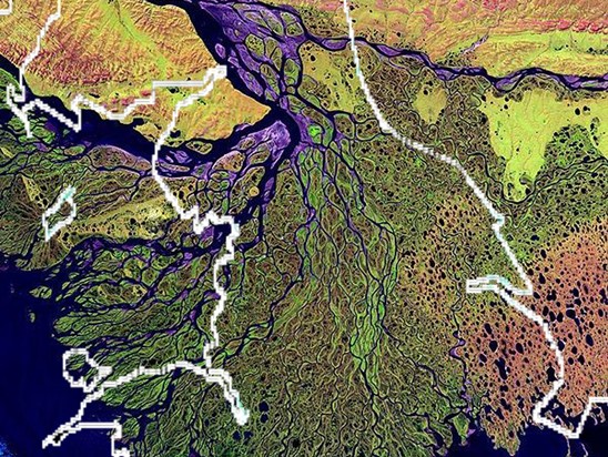
We believe that sediments, mainly sands, silts and muds, were eroded from hills in an area that now includes Scandinavia and Greenland and were swept into vast river deltas and lagoons in a central basin in a position now occupied by the Pennines. The sediment settled to the bottom as the water slowed down in the deltas and lagoons. The nearest equivalent sediments of today are forming in huge river deltas such as the Mississippi delta.
Diagram of delta
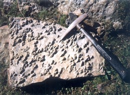
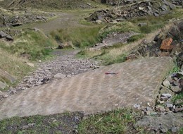
This sediment built up until it was hundreds of metres thick and was gradually compacted and cemented into the “sedimentary” rocks we know today. To geologists they form part of the Millstone Grit series. The overall thickness of sediments indicate infilling of a tremendous basin, yet features in the rocks, such as ripples like those on a beach, show shallow water conditions, so sediment infill must have kept pace with large-scale subsidence.
Photos of ripples on flags and fossils evidencing shallow water conditions
The age of these rocks has been determined by fossil comparison and radioactive dating at 320 to 315 million years. Geologists refer to this period of the Millstone Grit series as the Upper Carboniferous, about the middle period of obvious life on earth.
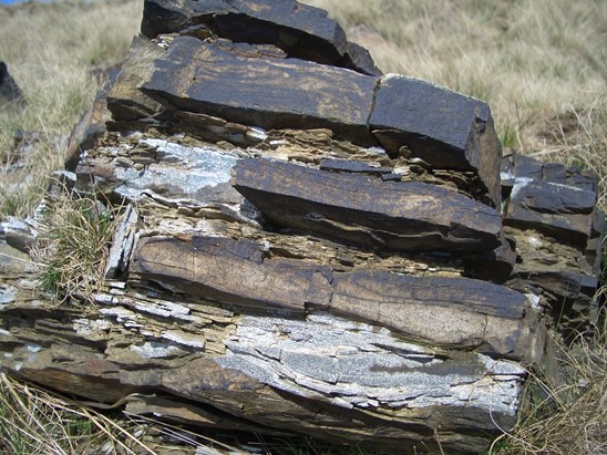
All Rossendale’s rocks are layered or “stratified”. This is because over the years conditions changed leaving different layers in the sediment. Sometimes the sediment would be mud, whilst at other times it would be sand. There were even times when pebbles were washed down to form a layer of pebbles mixed with sand. The different layers eventually turned into rocks with different properties. Coarse grained sedimentary rocks, perhaps containing pebbles, are known as gritstones, but in the past have been called ‘grits’ leading to the name Millstone Grit; medium grains equal ‘sandstone’; finer grains give rise to ‘siltstones’. The finest grained sedimentary rocks were once mud and are often dark coloured. Formerly known as ‘shale’ they are now referred to as ‘clayrock’. Typically the rock sequence is alternating layers of strong brown sandstones, softer dark shales (clayrock) and occasional gritstones.
Photos showing alternating strata of silt and sands at Thurns Head
At times, tops of deltas were colonised by vegetation and extensive peat swamps formed (perhaps like the Everglades of Florida today) which were later compressed to form the coal seams of the area.
Whilst the general process that gave rise to sedimentary rocks was the same over the whole of the Pennines, conditions would vary from place to place giving rise to local variations in the type and sequence of rocks. Peculiar conditions in what was to become Rossendale gave rise to deep beds of hard sandstones, known geologically as Haslingden Flag. This stone has a hardness and silica content equivalent to granite and was the principal reason for the growth of quarrying in Rossendale.
Haslingden Flag is of particular interest to geologists. Detailed geological mapping shows the shapes of the Millstone Grit deltas. The two most common types are found throughout the Pennines, but a third type is recognised only in the Haslingden Flags in Rossendale. This is an elongate delta: the nearest modern equivalent is the Mississippi / Everglades ‘Birds Foot’ type delta. Because it shows evidence of this rare type of delta, Lee Quarry is designated as a Site of Special Scientific Interest (SSSI).
