The main block of this quarry extends between SD 875 261 and SD 885 254. They lie close to the series of springs that are the source of the River Irwell, north of Bacup. The quarries are on the south-west edge of Heald Moor at a substantial distance from Deerplay Hill, and it would seem likely that they may be more correctly identified with the Heald Slate Quarries ( Davies 1985-96: Deerplay entry). Deerplay Hill Quarries are situated approximately one kilometer to the west at SD 862 267. The area was formally part of the medieval pasture land of Deerplay, adjacent to the Bacup vaccary (see Tupling 1927, 20; VCH Lancs xi, 437n6), which was gradually enclosed during the post medieval period. No tithe survey was compiled for this area.
Historical Summary:
Working Life: there may have been stone quarrying in the area from the sixteenth or seventeenth centuries. The quarries were near their final size by the 1840s and disused by 1893.
Quarry firms: Lords, and Blezzards owned Heald Slate quarries (Davies 1985 – 96 Deerplay Hill entry).
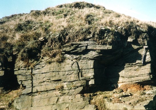
Geology: Dyneley Knoll Flags. Methods: hillside outcroppings. Transport: horse and cart.
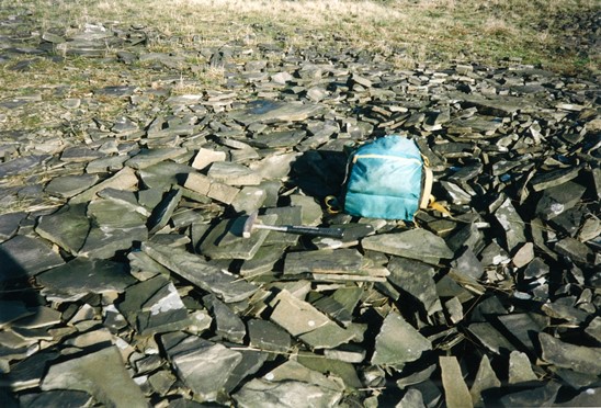
Products: included roofing slate (to all parts of country) Davies 1985-96 – Deerplay Hill entry).
Events:
1601 Plan of Horlaw Head and Cliviger Common shows a series of stone quarries running from Deerplay Hill to Tooter Hill. One of these quarries may relate specifically to this site, ‘ a stone of the salatte pites’ (ie Slate Pit) which is shown situated somewhere north of ‘the graffe dytche’ (presumably Greave Clough).
1848 OS 1st edn 6” (sheet 72) shows series of quarries labeled from north to south: ‘Sandstone Quarry (Flags)’, ‘Sandstone Quarry (Flags and Ashlar)’. 1850 Heald slate quarries (and Deerplay Hill quarries) in full production (Davies 1985-96)
1893 OS 25” map shows ‘Old Quarries’ and ‘Old quarry’.
1909 OS 25” map shows as 1893 map.
1923 OS 6” geology map (sheet 72NE) shows quarry in Dyneley Knoll Flags of Lower Coal Measures, NW group labelled ‘Flags with Sandy Shale Partings’; SE group, Micaceous Brown Flagstone’.
1928 OS map shows as 1909 map.
Summary of surviving remains: The group of quarries are hillside outcroppings with a series of small working faces, broadly lying on the north side with the spoil tipped down the slope to the south. The spoil heaps are extensive and relatively undisturbed. The main approach to the quarries is from Heald Lane with a trackway running along the south side of the area. Identified quarry features include the foundations of several structures (quarrymen’s shelters or storage, earthwork platforms and possibly processing areas, and a leat. The foundations of ‘Top’ cottages, seen on the OS maps from 1844-7 to 1928, were also located here.
