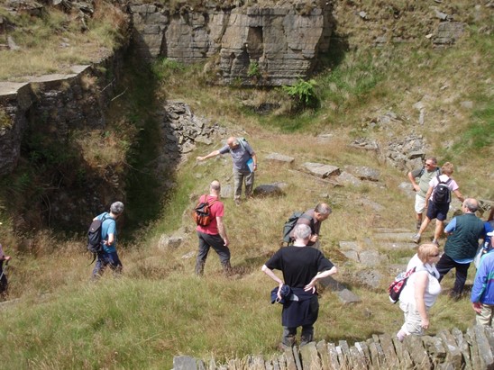
Thurns Head Quarry lies between SD 872 190 and SD 878 185, on the southern edge of the Cowm valley with Cow Clough Pasture to the west and Goats Hill Rough to the south. Historically, the quarry lay within the Whitworth Lower End subdivision of the Spotland township (Rochdale parish, formerly the manor of Rochdale).
Historical Summary
What now appears as one quarry was historically developed as three quarries: Thurns Head, Hey lane and Goat’s Hill.
Working Life: All three quarries were established by 1844-7. they were disused by 1928.
Quarry firms: Robert Jackson and Sons (Davies 1985-96).
Geology: Lower Haslingden Flags.
Transport: A tramway (single track) ran ¾ mile to Hall Fold staithe. (Allegedly A. Baldwin - it was 2’ 6” gauge and had iron wagons which carried 4 tons, with a loose body that was lifted off by crane. It ran by gravity (hand-braked) down to staithe, and was hauled back up one wagon at a time (Davies 1985-96).
Methods: Hillside outcroppings and mining (Davies 1985-96, Bill Kearns- pers comm.).
Products: Details not known - presumed same as neighbouring quarries.

Events: 1844-7: OS 1st edn (sheet 80) shows three discrete quarries; ‘Thurns Head quarry (Sandstone)’, ‘Hey Lane Quarry Sandstone’ to the north of Hey Lane and ‘Goat’s Hill Quarry (Sandstone)’ south of Hey Lane. A ‘Smithy’ is marked at Cow Clough (where work was done for the quarry see Douglas 1983).
1890: accident involving blasting (Davies 1985-96).
1893: OS 25” map (sheet 80.8) shows ‘Thurns Head Quarry’, ‘Hey Lane’ and ‘Goat’s Hill’, now merged, and Hey lane itself now a track into the quarries and possibly following the line of the earlier workings of Hey Lane Quarry (see OS 1844-7). A tramway is shown running through the quarries and leading south (on high barn Lane) to Hall Fold; one branch of the tramway continues north to the quarries on Ragstone Brow. Buildings and ‘Cranes’ are also marked.
1906: Accident to foreman, Robert Mills, engaged in ‘mining’ work at quarries of ‘Messrs Robert Jackson’.
1909: OS 25” map shows ‘Thurns Head quarry’, ‘Hey Lane’ and ‘GoatsHill’, only slightly enlarged. Former tramway routes now apparently shown as trackways. A length of new ‘Tramway’ is shown at south-west corner of Thurns Head quarry running to a small marked ‘Quarry’, possibly a drift entrance. The main area of extension to the quarrying, since 1893, is the central north of Goat’s Hill quarry, where routeways had been constructed.
1923: OS 6” geology map shows a quarry in Upper Haslingden Flags.
1928: OS map shows ‘Thurns Head Quarry (Disused)’, ‘Hey Lane (Disused)’ and ‘Goat’s Hill (Disused)’, less tramway. A small quarry to the south-west of Thurns Head also appears disused. The extent of the quarries appears to be the same as that on the 1909 map.
Field Components Summary: Overview Thurns Head quarry comprises a moderately sized area of hillside outcropping and open pit works, with mine entrances for underground extraction of stone. The thee main working faces of Goat’s hill Quarry, Hey Lane Quarry, and Thurns Head Quarry all survive and there are several smaller working faces and five pit extraction sites. The remains of the tramway and trackways were clearly visible and the spoil heaps were well preserved with many multi-fingered heaps. The quarry may be approached by trackways from the east which follows the tramway leading to Hall fold. The quarry is extremely rich in associated quarry features. These include the remains of numerous structures and earthwork platforms (representing quarrymen’s shelters, storage buildings, and processing areas), heaps of part finished quarry products and stone offcuts, crane bases, and extensive tramway remains, which continue beyond the survey area.
